A humbling experience
More and more I regret
The places I've been to
How I envy you
Waves that always return
(Japanese Haiku)
 The Forceit, Coruscades
It’s 2 am and I can’t sleep. The deep, powerful roar of the river seems to have gotten louder again during the night. I try and check with my torch to see if the water level has indeed risen but the beam only lights up thick curtains of rain before vanishing into the darkness. Surely the water can’t have risen that much; it was already in major flood yesterday. How much higher can it get? I tell myself it is just that sounds seem louder at night because it is quieter, but it doesn’t help. Whatever the river is doing I will deal with it in the morning. What matters now is to get as much rest as possible.
It is now early morning and there is just enough light to discern the river. I turn around and have a look from inside my sleeping bag. Even before my eyes focus on the river I can sense it has come up. A lot. The bush I was using as a gauge yesterday is nowhere to be seen and the rock we stood on to check the rapid, almost two metres above the water, is now another large pourover. This is insane. Will it ever stop rising?

Steve checking out the bottom of Newland's Cascade on day 4. The next day, the boulder he's standing on was underwater.
I get up and walk down to check the extent of the damage. One rafter is already up and seems worried.
“Do you think it is safe to paddle today?” he asks.
I look at the big, breaking, surging waves immediately downstream, at the line you have to take to hit them just right, at the eddy boiling madly at my feet. “Dunno… Maybe in a raft. Don’t think a kayak would make it, though.”
I go back to where Rigel, Steve and I spent the night and wake them up. “S**t, it’s come up again!” says Steve.
Rigel doesn’t seem too worried. As he lost his boat yesterday, he will have to go down on a raft. Steve and I, however, will have to paddle down in our kayaks. I would rather wait a day for the level to drop but the rafting party is leaving today and Rigel is going with them. It is probably safer for Steve and I to go with them now rather than wait a day and then paddle the rest of the way only the two of us.
So here I am. Under a huge overhang by the Franklin river, in the heart of the Tasmanian wilderness. On the banks of one of the few remaining, truly wild rivers on Earth. One that has never - at any stage - been altered by humans. No farms in its catchment and no dams on its course. This means the floods here are quick and ferocious. Stories of the river rising eight metres overnight are not uncommon and flood debris are there to attest it. Look up long enough and you will see them, the tell-tale signs: the unmistakable scour mark metres above the waterline, a branche caught way up in the canopy, a large log wedged bewteen trees desperately clinging to the banks of a steep-sided gorge; each and every one of them a troubling reminder of the furious masses of water that regularly come rushing down these God-forsaken gorges, obliterating all before them.
Looking at the Franklin in full flood now, I am the unwilling witness of such a biblical event: trunks are being swiftly swept down the brown torrent and through holes that would easily surf and flip a fully loaded raft, then further past monster wave trains, with standing, breaking waves three meters from top to trough. I just can't take my eyes off this most humbling sight; in my entire life, I’ve never felt so small and insignificant.
And soon we will have to paddle through this…
Day 1
The trip had started well. The water level at the put-in on the Collingwood (a small tributary) was perfect and the weather typical of south-west Tasmania: overcast and cold, even though this is the middle of summer. In front of us were 105 kilometers of remote whitewater coursing through the heart of the Franklin-Gordon Wild Rivers National Park, with compulsory portages that can take up to six hours and sometimes involve rock-climbing with your boat on your shoulder. The boats fully loaded with nine days worth of food plus the camping and rescue gear, we made our way down the first few kilometers in silence, marvelling at the tea-colored water and the dense rainforest surrounding us, its exotic trees still laced in the morning mist.
The sun started piercing shyly through the clouds as we made our way down Descension Gorge, and by the time we got to our first camp at the Irenabyss, it was shining brightly. We quickly undressed and put our gear out to dry on the rocks while we had lunch. Even though the campsite was located six metres above the river we set up our tarp between massive logs deposited there during one of the floods the Franklin is renowned for.
The next day was supposed to be set aside to climb Frenchman’s Cap, one of the highest peaks in Tasmania at 1’440 meters. But this was just a perfect day, which is very rare in a region that boasts 300 days of rain every year. So we shoved a few muesli bars and a fleece in a drybag, slung it around our shoulder and were on our way. We probably wouldn’t make it to the top - 1’200 metres higher up - but hopefully we would get high enough to get out of the forest and gain some good views of the wilderness surrounding us.
We started at a good pace and quickly reached the ridgeline, thus gaining absolutely stunning views of most of South-West Tasmania, from Lake St-Clair all the way to the Ocean. We passed crystal-clear mountain streams cascading down precipitous gullies and deep, dark, beautiful alpine lakes. Adrift in these wild highlands, amidst a sea of peaks, I sensed a feeling of pure freedom not often experienced in everyday life.
But Frenchman’s Cap still beckoned. And because it is not only higher, but also a long way away from the Irenabyss, it took us longer than expected to get to the base of the Cap itself, which is a surprisingly impressive mountain.
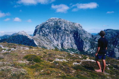
Frenchman's Cap (Note Rigel's sensible choice of footwear)
By that time it was already late afternoon, our legs were sore and it would have been wise to turn around then. On the other hand, this was probably a once in a lifetime opportunity. I might have come back here one day, but chances of having clear skies and no wind again were so small, it would have been a shame not to push on to the top that day, even if that meant making it back to camp in the middle of the night.
So after some scrambling on wet rock and walking past remaining patches of snow we finally reached the top. A stunning view of the land surrounding the Franklin awaited us: 360 degrees of uninterrupted wilderness stretching as far as the eye could see...
In some way we were also looking back in time, at what most of Tasmania would have looked like thousands of years ago: an ocean of trees, the deep ravines and steep ridges being the trough and crest of as many waves stretching endlessly to the horizon; a primeval land, so wild and inaccessible it would barely be surprising to come across a long-thought-to-be-extinct Tasmanian Tiger. A land so ancient and harsh and shrouded in mystery it somehow manages to be both beautiful and frightening at the same time. A terrible beauty.
We would have needed the whole day to take it all in but unfortunately for us, time was of the essence. As soon as we started walking down, my legs started cramping up with every step so I stopped often to stretch them and drink straight from pools on the ground. A few hours later, we stumbled into camp as the night was setting in. After a quick pre-cooked meal on a platform overlooking the narrow chasm of the Irenabyss, we slid in our sleeping bags and slept like logs amongst the logs.
Day 2
Getting up the next day was torture, our legs so sore from yesterday we could barely walk down to the water edge. Fortunately, today would be a no-portage day, letting the river carry us down as it cirumnavigates the massif of Frenchman's Cap. Grade III rapids carried us past hundreds-of-years old Huon Pines, further past picturesque waterfalls surrounded by huge fern trees, and the impressive Walls of Jericho, a formidable barrier effectively walling in the river, forcing it to shift its course from west to east. Quietly drifting with the current, I found myself daydreaming about what it would have been like to be one of the region's early explorers. Back in 1830 maps of Tasmania showed a blank area in the South-West - then known as the dreaded Transylvania - with the words “very little known about this country” written across it. Some of these ‘explorers’ were actually convicts escaped from the penal settlement of Sarah Island, or Hell on Earth as it was known back then. Looking at the dense, brutal bush around us - so much so that even aboriginals wouldn’t usually venture up here - helped me realize how bad the days on Sarah Island must have been. How tough does it have to be for someone to think a better alternative would be to try and escape through this country, barefeet and without food? One of these involuntary ‘explorers’, a ruthless man known as Alexander Pearce solved the food problem by asking other convicts to come with him, so that he could then kill them and eat them, which he did. He eventually made it back to civilization, only to be caught and then hung…
Not surprisingly the weather had turned. We were now under a steady drizzle so we started paddling harder in order to keep warm. I was glad we had pushed up to the top of Frenchman’s Cap the day before.
That night, we camped in a tiny, damp hollow in the ground, as the forest had already reclaimed most of the campsite.
Day 3
As easy as our second day had been, day three would be a whole different story. Indeed, we were entering a section known as The Great Ravine, or Deception Gorge. For the next eight kilometres, our only way out would be to get down the river, the walls on either side being too steep to attempt to walk out in case something went wrong. This was being made even more critical due to the fact that this stretch of river is the hardest, with long grade Vs and many grade IV rapids.
Once again, the weather was cold and wet. This added to our nervousness as this was the section of the river where the floods are the fiercest and can lock you in for days. The first grade V, known as The Churn, was a good warm up for the portages to come and took us only one hour as we decided to run the bottom drop, The Corkscrew.

The boulder in the background is about 3x3 metres.
A short distance downstream were The Coruscades, probably the longest runnable set of rapids on the river. Steve and Rigel ran it in full, including the pushy and tricky first drop. Had it been roadside, I might have run it. But then I remembered how very far away from help we were. I decided this was not the place to tempt fate and portaged. A few more drops and we got to Side Winder, quite dangerous as most of the water flows under a large undercut block. So we lined the boats down for an easy portage.
Once at Thunderush, the choice was ours. Option one was a 10 minute portage over large boulders on river left that ended at the top of a nasty-looking but thankfully short rapid. Option two, on river right, was possibly even riskier: a steep, exposed 6-hour portage track (and only marginally safer than running the grade V rapid, according to many). As it turned out, the bottom rapid on the left was not as bad as it looked and even though Rigel almost got stranded on a rock and I missed my line and went sideways into a hole, we all made it down in one piece.
The last major rapid was The Cauldron. After that we would be out of the Ravine and the rest would be easy, or so we thought. An easy portage option at low levels is to carry on the rocks on the right. Unfortunately for us, the level was too high for this. The eddy that is sometimes used by adventurous paddlers to get onto a boulder in the middle of the current, and from which you can then seal launch into a sneak chute, also looked too hard to make. So we bit the bullet, unloaded the boats and scrambled up the cliff to Eagle’s Nest camp.
 Eagle's Nest Camp, Great Ravine
We managed to get the boats up and stopped for lunch. It was almost 4 in the afternoon and Steve suggested we should spend the night here. We were all very tempted to give our exhausted bodies a rest but since the weather could turn to heavy rain anytime, we decided it would be safer to push through the rest of the Gorge today.
So we put the boats back on our shoulders for the rest of the portage. We climbed up a steep, slippery track, struggled through vines and over and under logs, using the throwropes to drag and lower the boats whenever the track got too steep. We then had to walk back to get our drybags, paddles and tarps before reloading the boats and lowering them down a 15-meter cliff to a slot in the rock. Finally, we downclimbed to the water, using anything from slimy, mossy holds to small, prickly shrubs in order to reach the bottom.
Out of The Great Ravine at last, we made our way down to Rafter’s Basin, where we set up camp only a meter or two above the waterline, hoping for a dry night. But as soon as we put our heads down to sleep, rain started pouring down on the tarp and I went to sleep with visions of a flash flood carrying us down the river in our sleeping bags.
Day 4
Getting out of bed that next morning was made doubly painful by the portages the previous day and the persistent rain - and even hail. At about 11am the sun came out just long enough to lure us out of our sleeping bags before disappearing again.
Not surprisingly, the river had risen a good metre (even though this was a very wide section) and the small grade II rapids of yesterday were now pushy IIIs. We made our way down on fast, confused water creating boils and whirlpools that would often make us spin around out of control, making us feel powerless against the multiplied force of the current.
Some rapids had washed out and went unnoticed, while others had been magnified greatly. A minor rapid known as Ol’ Three Tiers made us stop and stand in awe: we were looking straight at a Zambezi-sized, 3 meter high breaking wave!
It looked possible to cut across hard to the left and through a curling wave feeding right into the guts of it. But that was underestimating the power of the water. I hit the curler straight on but to my ever-lasting incredulity, got washed straight into the monster wave. I braced myself, set on trying to roll at least once before being ripped out of my boat. As I went through it, I felt the green water hit my blade so I did a quick hip snap and found myself upright and clear, in a perfect position to sidesurf the next wave, which spit me almost right into the eddy. Unbelievable! Rigel went down next, got spun around and went in backwards, looking like he was trying to surf the beast!
 Ol' Three Tiers at high flow (Rigel in the center)
 Steve, seeing there wasn’t much that could be done to avoid it, went straight down the middle and got through OK.
Then we portaged The Pig Trough and put in at the bottom of it, just upstream of what is probably the single most beautiful spot on the river, the famous Rock Island Bend: a small, tree-covered island of rock set right in the center of a bend in the river. It would have been a good spot for contemplation and congratulate ourselves on making it down the hardest part of the river but it was far from over. The put-in was the focus of all our attention: usually a large pool of gently swirling currents, it was now a confused mass of surging, boily water. And a hard ferry was needed to get into the main current. Go a little too high and you’ll be sucked into a large hole. Too low and you won’t make it across the powerful wave train and smash into the cliff immediately downstream. I tried first but as soon as I crossed the eddy line, the current spun me around and straight towards the cliff. I made a desperate stroke to catch the eddy again and just made it. Rigel tried next, got spun around, capsized and washed against the cliff, got spat out and rolled up. I tried again, got washed against the cliff sideways, sidesurfed the pillowing wave for dear life until it threw me out into the current. Steve went under but rolled up.
Newland’s Cascades was next. Usually a grade III-IV set of rapids, it had become a continuous, fast section of hard grade IVs for about 300 meters, with two nasty recirculating eddies/holes on each side of the final drop. I took one quick look at it and classified it as a definite portage. But Rigel and Steve decided to run it so I thought I might give it a go if they went down OK.
Rigel went first and, unbeknownst to us, got caught in the nasty bottom hole, got his deck popped by the water and got ripped out of his boat before he could even try and roll. A raft guide from a group camping there threw him a throwbag but had to let go as the current was too strong. Rigel then tried to swim for shore but had to let go of his boat and paddle as he was about to enter another large rapid. Unaware of what was happening downstream, Steve went down. I almost followed him but decided it wouldn’t hurt to make sure he made it down OK before setting off.
Well, let’s just say I’m glad I did. Steve got through the bottom hole but got sucked back into the left eddy and went for the ride of his life. He tried to hold on and went for a wild ride before having to wet exit. He then swam deep in order to catch the green water and came out some meters downstream while his boat washed into the eddy where Rigel was now stranded. One of the raft guides walked up to tell me it was “carnage city” down there so I gladly portaged (after all, this was a perfect excuse not to run it).
Two paddles and one boat down, we spent the night with the rafting party under a large overhang, out of the rain for the first time in days.
Day 5
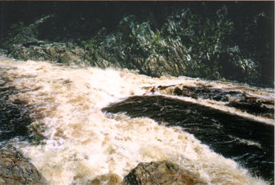
And now here I am. So scared I feel like I’m going to be sick. With no option but to run the wild Franklin in full flood. Tim, who has been guiding on it for six years, has never seen it this high and we are all looking at the river in a mix of awe and fear, humbled by its immense power. But as scared as I am, I am also strangely excited. After all, this is what most of the rivers would have been like before the coming of dams: an uncontrollable force. Mother Nature in all its glory. And looking at the Franklin now is a bit like looking straight down a cliff. It is both scary and exciting at the same time. It makes you want to stand back but also draws you to it, uncontrollably. Appalling and appealing.
The rafters are ready to go and Steve and I will have to go first. "C'mon" says Steve, "they're probably the biggest waves you'll ever get to paddle!"
At the put-in, the roar of the water is almost deafening and I have to yell for Steve to hear, only a meter away. He peels out first and I follow him closely. A few powerful strokes to get some speed and I hit the big surging wave at the right time and get through and down the other side. As I slide down the back of it, everything goes dark around me. Dark and silent. Now in the trough, the massive standing waves are forming a wall against the confusion of light and noise. I am in a different world. A world strangely serene and chaotic at the same time. A world in which water seems to have suddenly frozen, hence holding its shape as I glide on it, way up the face of one wave and deep down the other side, to the bottom of yet another fantastic mountain of water towering above me.
I turn around at the end of the rapid to see one of the rafts has indeed been flipped (the wave surged at it was cresting it). The clients are swimming for the second raft while Rigel jumps on the overturned boat to help flip it back the right way. Big wave indeed…
A bit further down we find Rigel’s boat washed up in an eddy, but without a paddle he has to keep going on the raft.
We pass the Cromleigh Cliff in the distance before stopping to check out the Kuti Kina cave, which aboriginals used for ceremonies called Corroborees 10,000 years ago. It was the southernmost human habitation in the world during the last ice age and their presence can still be felt. We keep floating down and share some soggy chocolate found in Rigel’s boat. The landscape has flattened some and the river is now so wide it looks somewhat like the Amazon, flowing steadily between dense rainforest lining up the banks all the way to the water’s edge. Eddies and pools so large it is sometimes hard to see where the river is going. The level is so high that we go over Big Fall (usually a 2-meter drop and a compulsory portage) without noticing the slightest ripple. From time to time, huge boils and whirlpools appear out of nowhere, spinning us around and keeping us on our toes…
Soon we meet the Gordon and a couple of great wave trains later we get to Sir John Falls, where the yacht “Stormbreaker” will pick up Rigel and the rafters in the morning.
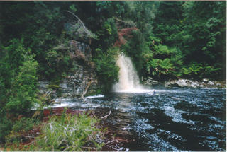 Sir John Falls
Opposite Sir John Falls is an old jetty, a stark reminder of how close we came from losing the Franklin forever. In the 1980’s, a project of damming the last wild rivers took form and barges started unloading bulldozers to build a dam on the Gordon, sealing the fate of the Franklin in the process. Fortunately for us, people from all over the world gathered here and fought for months for what they knew was right. Using small inflatable boats, they courageously stood in the paths of the barges and got thrown in jail, then came back again. In the end, and with the help of the Wilderness Society, the blockaders managed to attract enough public attention and the damming was eventually stopped. How anyone could ever think of destroying such a beautiful place is beyond my understanding… To read more abou this issue, click on the link below http://www.wilderness.org.au/campaigns/wildrivers/franklin/franklin/
Day 6
In the morning, Steve and I watch the yacht leave, slightly envious as we know Rigel will be enjoying breakfast, reading the latest news and cruising down the majestic Gordon when we will have to paddle twenty-two kilometers of flatwater to catch the ferry at Heritage Landing. But we can’t complain, really: the scenery is gorgeous once again and the sun is shining. How many people are looking out the window right now wishing they were in our shoes?
After a week away from civilization, the 3-stories high ferry looks like nothing less than a large space ship unloading its load of aliens. The tourists look at us in astonishment, one kid even poking Steve to make sure this rough-looking, smelly human-like creature is for real…
Soon the captain deftly turns the boat around and we are on our way back to civilization. This is it, I tell myself. We have just paddled the Franklin River. The wild, untamed, beautiful Franklin.
Standing up on the top deck at sunset, staring at the vast expanse of Macquarie Harbour before me, the imposing pyramid of Frenchman’s Cap sticking out of an ocean of peaks on my right, I feel blessed to have been given the chance to complete the descent of what is often described as one of the greatest river adventures left on Earth. I’m at peace.
But as content as I am I also feel a trace of sadness, as I remember the prophetic words of Edward Abbey: “When I return will it be the same? Will I be the same? Will anything ever be quite the same again? If I return.”
Special Thanks to:
Rigel “Hole Dog” Butler for running most of the crazy stuff first and no doubt sparing me from a few swims.
Steve “Chafy” Oakes for the yummy beef jerky, carrying some of my gear and also sparing me from a swim at Newland’s Cascades.
Sarah “Bella” Watson for lending me her boat and doing the shuttle, all with a smile on her face!
Finally, my ever-lasting gratitude goes to those who fought to save the Franklin during the 1982-1983 blockade. Without them, this wonderful and mystical river would have been lost forever.
Reading: "Death of a river guide", by Richard Flanagan. A most beautiful book on Tasmania and a tribute to the Franklin. A must-read if you ever venture that way.
posted by Jean @ 11:46 AM
0 comments
![]()

0 Comments:
Post a Comment
<< Home